|
| |
HISTORICAL
BACKGROUND
In
ancient days Jhelum was known as Jalham, the word Jhelum is reportedly derived
from two words JAL(pure water) and HAM(snow).
The name thus refers to the waters of river Jhelum which have their origin in
the snow capped Himalayas. The name of this river written in Rag-e-Vaid is
Watasta. The origin of this river is Vary Naag Spring in Sri Nagar from where it
enters Wooler Lake. After passing Wooler Lake it then enters Mangla Lake. The
total length of this river is 450 Miles. Two canals named Upper Jhelum and Lower
Jhelum are also constructed from this river.
Jhelum is one of the oldest districts of Pakistan, established by the British
Regime in the year 1849 with its Headquarters at Pind Dadan Khan. At that time
it consisted of Chakwal, Jabbi and Pind Dadan Khan. Subsequently, Jhelum
replaced Tehsil Jabbi and also became the District Headquarter in 1850, In 1949
the Tehsil of Rohtas was also transferred to this District from Rawalpindi. In
1850, Makhad and Pindi Gheb area of this Tehsil were added to Talagang Tehsil.
In this way Jabbi Tehsil was abolished that year and a new Tehsil was
constituted. The same year the Headquarter of the District was shifted from
P.D.Khan to Jhelum. P.D.Khan was relegated to a Sub-Division. In 1851 Jabbi area
was transferred from Rawalpindi District to this District. In 1857, sixty five
villages were again transferred from Rawalpindi District to Jhelum District.
Afterwards, the Tehsil of Talagang was transferred to Cambellpur District.
Presently named as Attock District. Thus at the time of independence, the
District consisted of three Tehsils Jhelum, P.D.Khan and Chakwal covering an
area of 2772square kilometers.
Jhelum
District is situated in the north eastern parts of Pakistan and is one of the
four districts of Rawalpindi Division. During the year 1992 Chakwal District was
created. In this way a good part Jhelum District was detached. At the same time
Jhelum Tehsil was bifurcated in two parts by creating a new Tehsil of Sohawa out
of it.
LOCATION
& BOUNDARIES
The
District contains four towns :-
Jhelum City
Dina
P.D.Khan
Sohawa
The
Administrative Headquarters are at
the town of Jhelum that is situated in the extreme South Eastern Corner of the
District. There are three Assistant Commissioners stationed at Jhelum Saddar
P.D.Khan and Sohawa.
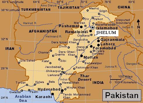
It
is situated in the north east of Punjab, Jhelum straddles both sides of the
Grand Trunk Road. It is bounded in the north by Rawalpindi District, in the
South by Gujrat and Sargodha, in the east by Azad Jammu & Kashmir and in the
west by District Chakwal from which it is separated by a mountainous range
called the Kohistan-e-Nimak.
The river passes through the Eastern & Southern parts of the District. The
soil adjoining the river is generally plain, alluvial and quite fertile. This
area is generally cultivable and produces all types of crops. The western edge
of Tehsil P.D.Khan is both exceedingly rough and difficult in approach making
this area relatively inaccessible. The newly constructed Motor Way has now
opened up this area. The area of District is as below:
|
TOTAL AREA OF THE DISTRICT |
CULTIVABLE AREA |
UNCULTIVABLE AREA |
|
858,767 Acres |
316,810 Acres |
541,957 Acres |
In terms of Sq.Km the total area of the District is 3,587.
PHYSICAL
FEATURES
There is a long stretch
of plain level around Jhelum itself, which is prolonged into a narrower strip
along the course of the river, which is overlooked by hills, whereby the
mountains of the Salt Range and its off shoots cut the District and divide it
into two District lines of hills generally situated at a distance of about 8
kilometers from each other. Each of these is made up of a number of parallel
ridges. Generally, after an interval of 16 kilometers these two main lines of
hills bound in toward one another. Then they again separate, again run parallel
and unite.
BACK TO TOP
TOPOGRAPHY
Geographically Jhelum
is divided into three regions, the first of these lies below the hills, the
second within these and the third behind these. These regions may be called as
the riverine, the upland and the plateau.
The riverine region possesses
alluvial soil and is situated between the river Jhelum and the hills in the
southern part of the District. Its length is 160 kilometers and stretches from
Pindori in tehsil Jhelum to Phitrote in District Sargodha. The narrow plain
between the Salt Range and the Jhelum situated beyond Jalalput Girjak contains
the most fertile land. this area is very productive and produces all types of
crops.
The second Upland region is
the tract, which lies between ranges of the hills. The uplands of the Salt Range
live together in Pind Dadan Khan Tehsil, while those which are situated between
the Tilla and the Nilli hills, are surrounded by mountains from all the sides.
In some places the surface is too stony to be productive but generally the soil
is of good quality.
The third region is plateau. It is
quite different the first one. It consists of most parts of Domeli and Iskandral
area. It is generally known as Khudder of area of riverines. The surface of the
tract is broken and distorted. On the both sides of Bund stream the land is high
and sandy. Near Baragowah the soil is mixed with clay. Just under the soil is
too stony to be culture able, but the soil is very rich and fertile on the banks
of kahan stream below Rohtas. Between Lehri and Langerpur hills soil is black in
colour.
FLORA & FAUNA
Vegetation of the
forests of Jhelum Forest Division is dry deciduous scrub type, Phulai, Kau and
sanatha are the main species. The stocking on the whole is poorand the forests
are open. Vegetation is poor on sand stone and redmarl. The southern slopes are
often devoid of vegetation while north western slopes carry good forests. The
forests of Jhelum Forests Divisions are burdened with right of grazing browsing
and firewood. Under settlement out of total area 93,566 acres only 5,468 acres
about (45%) are right free. Remaining 55% are open to grazing.
The fauna of the
District is mostly indigenous restricted, like the vegetation, but similarly
varied and interesting. The rugged and rough terrain, low rainfall, the scantly
cover of vegetation and the burning passions of the increasing number of
hunters, all have their share in limiting the animal kingdom in the District.
The riverine offers a better environment than elsewhere though the hills support
a more interesting wildlife. Urial and Chinckara are spot aids while wild bores
are found in the Salt Range. Wolves, Foxes and Wild Cats are also found. Hare is
fairly common. Chikor grey and black Patridge are also found in the parts of the
District. Migratory ducks like Teal Pintail and Mallard and some geese visit
during winter.
ETHNOGRAPHY
The general
distribution of the land owning tribes comprised of Gujjars who hold east of the
Jhelum and present Sohwa Tehsil. Janjuas the south west and the Gakkhars in the
great part of what remains. In P.D.Khan, Janjuas hold most of the eastern half
of the hills and some of the eastern plain. The rest of the plain is held by
Jalps,Kashmiris, Mughals, Qureshis, Awans, Syeds, Phaphras, Khokhars etc.
AGRICULTURE
Jhelum District has a
total area of 8,58,767 acres, out of which 3,16,815 acres are cultivated. It has
three tehsils viz; Jhelum, Pind Dadan Khan and Sohawa. The area is located on
the eastern part of Potohar upland alongwith River Jhelum.
Agriculture in the
District Jhelum depends mainly on rainfall. The average rainfall of the area
varies from 20 to 40 inches. About three fourth of this precipitation is
received in monsoon season and the remaining one fourth is received during the
rest of the year. The irrigated area at present is limited but the emphasis on
construction of small Dams and Mini Dams is gradually increasing. Wheat remains
the main crop.
In Tehsil P.D.Khan Salt is the predominant feature which is
spoiling the rich agricultural land day by day. There is a long strip of very
rich and virgin soil along the river which could be made a paradise of citrus
plantation by drip irrigation if the local people are motivated and the
Government of Punjab expressed some interest in it.
LITERACY
The Literacy ratio in
Jhelum District has increased from 38.9% in 1981, to 63.9% in 1988. The Literacy
ratio for males is 77.7% as against 50.5% for females. The ratio is much higher
in urban areas when compared with the rural areas for both male and female.
Literacy
Ratio By Sex And Rural/Urban Areas
|
AREA
| BOTH SEXES
| MALE
| FEMALE
| All Areas.
| 68.9
| 77.7
| 50.5
| Rural.
| 58.6
| 74.3
| 44.4
| Urban.
| 77.2
| 84.9
| 68.0 |
| | |
BACK
TO TOP
COMMUNICATOINS
ROADS:
All the three tehsil
headquarters are interlinked with metalled roads. The tehsil Sohawa is situated
at Grand Trunk Road whereas Pind Dadan Khan Sub-Division is connected with
Jhelum-Pind Dadan Khan Road. The suburbs of Jhelum Tehsil stand linked and
netted with pacca roads namely Gattalian-Sheikhupur road, Jhelum-Kala
Gujran-Chak Jamal Road, Chak Jamal-Boora Jungal road, Dina-Sheikhupur-Mangla
road, Nakki Link road, Pind Dadan khan, Rohtas road, Umral Lehri road, Sohan
Johda road and Khalaspur Chakri-Pind Swika road. The Sohawa Sub Division is also
interlinked with the villages of Bhitmast, Pakhwal, Dhidi PariKarunta-Bangi,
Gurha Nisar, Domeli, Jahli, Adrana, Dhoke Mochian, Gattarand Gujjar Katarian.
Pind Dadan Khan town inter-links the villages of this Tehsil on eitherside of
the left and right with small pacca roads.
RAILWAYS:
There is one main Railway line passing
through the District connecting Lahore, Wazirabad, Rawalpindi and Peshawar. One
branch line coming from Malikwal enters the District at Haranpur after crossing
the river Jhelum.One branch line leads to Gharibabad, One to Khewra, One to Pind
Dadan Khan laeving for Khushab through Lilla and one branch line leading to
Mangla Cantonment and Maira from Dina. The total length of Railway lines passing
through the District is around 100 kilometers.
POSTAL SERVICES: The
postal services are satisfactory, especially since the involvement of private
sector. Similarly the telecommunications have also been improved because of the
Government policy to encourage the private sector even in the remote areas of
the District. Communication has also become satisfactory with improved equipment
and introduction of new technology.
BACK TO TOP
The Health Department
is maintaining one District Headquarters Hospital at Jhelum, one Tehsil Hospital
each at Pind Dadan Khan and Sohawa Tehsil, Six Primary Rural Health Centers,
five sub-Health Centers, Seven Primary Dispensaries, Eight M.C health Centers,
Forty Basic Health Units, One T.B.Center, 52 Dispensaries in which Eight
Doctors, Ten Women Medical Officers, Dental Surgeon, Three Rural Health
Inspectors are working. There is also one Para Medical Institute at District
Headquarters, Hospital for imparting training to the lower Medical Staff. The
Zila Council is also running 9 Dispenceries, Two MCH centres and 19 Veterinary
Hospitals, The Fauji Foundation has also established a hospital at jhelum city
for providing facilities to the retired army personnel and their dependents.
BACK TO TOP
The climate of the tract is extreme. In
winter it is very cold and summer is very hot. The average rainfall varies
from 48 to 69 m.m per annum which is much below the required quantity but in
the rainy season the water torrents flow from North to the river Jhelum with
a very fast speed and cause damages to the crops, bridges, roads and are
responsible for the soil erosion in the District. The detailed data is as
under:
MONTH WISE TEMPERATURE &
PRECIPITATION
| MONTH
| MAXIMUM TEMP.
| MINIMUM TEMP.
| PRECIPITATION(m.m).
| JANUARY.
| 24.0
| 1.8
| 118.4
| FEBRUARY.
| 26.9
| 3.5
| 117.4
| MARCH
| 32.5
| 7.4
| 261.0
| APRIL
| 39.4
| 12.4
| 144.1
| MAY
| 43.7
| 16.8
| 89.1
| JUNE
| 45.7
| 21.1
| 148.9
| JULY
| 42.2
| 21.8
| 502.5
| SEPTEMBER
| 38.2
| 18.8
| 252.3
| OCTOBER
| 36.3
| 12.4
| 61.5
| NOVEMBER
| 31.5
| 5.4
| 40.1
| DECEMBER
| 25.9
| 12.1
| 186.3
| YEAR
| 35.4
| 12.1
| 1239.3 |
| | | | | | | | | | | |
SOURCE : - District Census Report Of Jhelum

|